Please refer to Assignments Class 10 Social Science Resources and Development Chapter 1 with solved questions and answers. We have provided Class 10 Social Science Assignments for all chapters on our website. These problems and solutions for Chapter 1 Resources and Development Class 10 Social Science have been prepared as per the latest syllabus and books issued for the current academic year. Learn these solved important questions to get more marks in your class tests and examinations.
Resources and Development Assignments Class 10 Social Science
ONE MARK QUESTIONS
Question. Give examples of biotic resources.
Ans : Human beings, flora, fauna, fisheries, livestock, etc.
Question. In which states laterite soil is found?
Ans : Karnataka, Kerala, Tamil Nadu, Madhya Pradesh, and hilly areas of Odisha and Assam.
Question. Which relief features of India has 30 percent of the total surface area of country?
Ans : Mountain.
Question. In which states is black soil found?
Ans : Maharashtra, Saurashtra, Malwa, Madhya Pradesh and Chhattisgarh.
Question. Which soil is ideal for growing cotton?
Ans : Regur soil.
Question. In which states overgrazing is responsible for land degradation?
Ans : Madhya Pradesh, Rajasthan, Gujarat and Maharashtra.
Question. Which state has the largest area under black soil?
Ans : Maharashtra.
Question. What are resources which are found in a region but have not been utilised called?
Ans : Potential resources.
Question. In which states has mining caused severe land degradation?
Ans : Jharkhand, Chhattisgarh, Madhya Pradesh and Odisha.
Question. What is the percentage share of plains in the total land area?
Ans : 43%.
Question. Which resources are surveyed and determined on the basis of their quantity and quality for utilisation?
Ans : Developed resources.
THREE MARKS QUESTIONS
Question. Describe any five distinct characteristics of ‘Arid soils’.
Ans : a. Arid soils range from red to brown in colour.
b. Sandy in texture and saline in nature.
c. Evaporation is faster, soil lacks humus and moisture.
d. Soil occupied by Kankar.
e. Kankar restricts the infiltration of water.
Question. Mention any three features of arid soils.
Ans : Features of arid soils :
1. Arid soils range from red to brown in colour.
2. They are generally sandy in texture and saline in nature.
3. Due to dry climate, high temperature, evaporation is faster and the soil lacks humus and moisture.
4. The lower horizons of the soil are occupied by Kankar because of the increasing calcium content downwards.
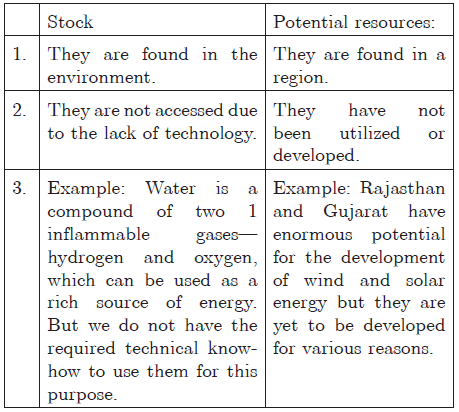
Question. Differentiate between stock and reserve stating two points of difference.
Ans : a. Stock: Materials, which have the potential to satisfy human beings but human do not have the appropriate technology to access these, are termed as stock. We do not have the required technical ‘know-how’ to use them for a specific purpose, e.g., water which is a compound of two inflammable gases hydrogen and oxygen and can be a rich source of energy. We do not know how to use them.
b. Reserves: These are subset of the stock. They can be put into use with existing know-how but their use has not been started. For e.g., river water is used as a source of hydroelectricity but to a limited extent. Thus, the water in the dams, forests, etc., are reserves which can be used in the future.
Question. ‘Land is a natural resource of utmost importance’. Justify the statement with appropriate arguments.
Ans : a. We live on land, we perform our economic activities on land and we use it in different ways.
b. It supports natural vegetation, wildlife, human life, economic activities, transport and communication systems.
c. It is an asset of a finite magnitude.
Question. What is meant by the term “resource”? List the types of resources classified on the basis of its ownership.
Ans : a. Resource: Everything available in our environment which can be used to satisfy our needs, provided, it is technologically accessible, economically feasible and culturally acceptable is known as a resource.
b. Types of resources on the basis of ownership are: Individual, community, national and international.
Question. Distinguish between the renewable and nonrenewable resources.
Ans : a. Renewable resources: Resources which can be renewed or reproduced by mechanical, physical or chemical processes are known as renewable or replenishable resources, e.g., solar and wind energy, water, forests and wildlife, etc. b. Non-renewable resources : These occur over very long geological times. Minerals and fossil fuels are examples of such resources. These resources take millions of years in their formation. Some of the resources like metals are recyclable and some of them such as fossil fuels cannot be recycled and get exhausted with their use.
39. Distinguish between stock and potential resource. Give one example of each.
Ans :
Question. What type of soil is found in the river deltas of the eastern coast? Give four main features of this type of soil.
Ans : Alluvial soil is found in the entire northern plain It is the most widely spread soil of India. Main features of alluvial soil:
a. It is formed by the deposition of materials brought down by the Himalayan rivers.
b. It is highly fertile.
c. It consists of various proportions of sand, silt and clay.
d. It is rich in potash, phosphoric acid and lime but deficient in organic matter.
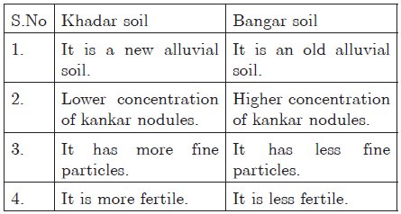
Question. Distinguish between Khadar and Bangar soil. or How are alluvial soils formed? How is Bangar different from Khadar?
Ans : Alluvial soil: It is soil formed by the sediments deposited by river water.
Question. Explain any three factors responsible for soil formation.
Ans : a. The parent rock is the first factor which provides the basic material for the formation of soil.
b. Climate breaks the parent rock into small pieces.
c. Vegetation: Plant and animal organisms help in the weathering of the rocks slowly but continuously
d. Various forces of nature such as change in temperature, actions of running water, wind and glaciers, activities of decomposers, etc., contribute to the formation of soil.
e. Chemical and organic changes take place in the soil.
Question. Which geographical factors are responsible for the evolution of black soil? Why is it considered the most suitable for growing cotton?
Ans : a. Climatic conditions along with present rock material are important factors for making of black soil. The parent rock is volcanic rock.
b. It is ideal for growing cotton because of the following reasons:
c. It has capacity to hold moisture.
d. It is rich in soil nutrients such as calcium carbonate and potash.
e. Deep cracks in the soil help in aeration.
Question. Explain any three human activities responsible for land degradation in India.
or How are human activities responsible for the degradation of land?
Ans : a. Mining: Mining sites are abandoned after excavation work is complete leaving deep scars in states such as Jharkhand, Chhattisgarh, Madhya Pradesh and Odisha. Deforestation due to mining has caused severe land degradation.
b. Over irrigation: Over irrigation in the states of Punjab, Haryana, western Uttar Pradesh, has caused water logging and increase in salinity of soil.
c. Overgrazing: Overgrazing in states such as Gujarat, Rajasthan, Madhya Pradesh and Maharashtra is a huge cause due to cattle population d. Industries: Mineral processing industry like grinding of limestone for cement industry and calcite and soapstone for ceramic industry generate huge quantity of dust. This retards the process of infiltration of water into the soil. e. Industrial waste: Industrial effluents also have become a major source of land degradation.
Question. Mention any two human activities which are responsible for the process of soil erosion. Explain the two types of soil erosion mostly observed in India?
Ans : Two human activities which are responsible for the process of soil erosion are deforestation and overgrazing, mining, construction, etc. Types of Soil Erosion :
a. Gullies: The running water cuts through the clayey soil and makes deep channels/gullies. The unfit land caused by gullies is called bad land or ravines.
b. Sheet erosion: water flows as a sheet over large areas down a slope. The top soil is washed away .This process is known as sheet erosion.
Question. Explain the types of resources on the basis of exhaustibility with the help of examples.
Ans : a. Renewable resources: Resources which can be renewed or reproduced by mechanical, physical or chemical processes are known as renewable or replenishable resources, e.g., solar and wind energy, water, forests and wildlife, etc.
b. Non-renewable resources: These occur over very long geological times. Minerals and fossil fuels are examples of such resources. These resources take millions of years in their formation. Some of the resources like metals are recyclable and some of them such as fossil fuels cannot be recycled and get exhausted with their use.
FIVE MARKS QUESTIONS
Question. What is meant by ‘Land Resource’ ?
Ans : We live on land and it satisfies our needs in all the possible ways. Land resource, thus is, of much importance for us which includes forests, mountains, plains, plateaus and islands. These support natural vegetation, wild life, economic activities, and transport and communication systems. Therefore, it is necessary for us to use these resources in a wise manner and with careful planning, we should develop holistic and ecological approach towards economic development without compromising the ability of resources to future generations to meet their needs. Though we have the right to meet our present needs by consuming natural resources, we should not deprive the future generations from it.
Question. Explain land use pattern in India and why the land under forest not increased much since 1960-61.
Ans : Land in India has been divided into different categories with reference to usage. Different categories of land are:
a. Farming land which is used for farming.
b. Forest land which comes under forest area
c. Land meant for grazing
d. Non-farming land which is used for industrialization
e. Waste lands, such as rocky areas and deserts
The irrational use of forest land has degraded the available land area, and has made conservation of forests difficult. Human actions such as deforestation, mining and quarrying have contributed to the slow growth rate of forests. Thus, land under forest has increased by only about 4% since 1960-61.
a. The use of natural resources has been increased with the development of the technology in the country.
b. Over utilisation of soil due to development in technology.
c. Growth in the quality of production and better services to the people.
d. Improvement in the process of mining.
e. Demand for more resources due to urbanisation.
Question. What do you understand by the term ‘land degradation’ ? Which human activities lead to land degradation ? What are the measures to solve the problems of land degradation ?
Ans : Land resource is fixed and cannot be increased. Land resource has been used since the ancient time. This continuous usage of land over a long period of time, without taking necessary steps to conserve and manage it has resulted in land degradation. As a matter of fact, the quality of the land has become inferior due to regular loss of fertility and irregular usage. Human activities have also contributed towards land degradation. There are :
a. Deforestation i.e., cutting down of forests.
b. Over grazing.
c. Mining i.e., extraction of valuable minerals from the soil.
d. Mineral processing like grinding of limestone.
e. Faulty methods of cultivation and over-irrigation.
These damages can be prevented with the help of these measures :
a. Afforestation and proper management of grazing.
b. Plantation of shelter and stabilisation of sand dunes by growing thorny bushes in windy and arid areas like the deserts of Rajasthan.
c. Proper management of wasteland and control of mining activities.
d. Proper discharge and disposal of industrial effluents and waste after treatment in industrial and suburban areas.
Question. What is the purpose of ‘Land Utilisation’ ?
Ans : Land resources are used for the following purposes :
a. Forests.
b. Land not available for cultivation :
(1) Barren and waste land.
(2) Land put to non-agricultural uses, e.g., buildings, roads, factories, etc.
c. Other uncultivated land :
(1) Permanent pastures and grazing land.
(2) Land under miscellaneous tree crops groves.
(3) Cultural waste land’left uncultivated for more than 5 years.
d. Fallow lands:
(1) Current fallow land left without cultivation for one or less than one agricultural year.
(2) Other than current fallow land, left uncultivated for the past one to five years.
e. Net sown area, sown more than once in an agricultural year plus net sown area is known as gross cropped area.
Question. What are the main types of soil found in India ? Which type of soil is the most widespread and important soil of India ? Describe in detail about this soil type.
Ans : The main types soil found in various parts of India are as follows :
a. Alluvial soil
b. Black soil
c. Red and yellow soil
d. Laterite soil
e. Arid or Desert soil
f. Forest and Mountainous soil.
Alluvial Soil : Alluvial soil is the most fertile and extensively found soil in India. This type of soil is found near the river banks and is deposited by the rivers of India. The Indus, the Ganga and the Brahmaputra are the three main rivers which are responsible for its deposition and have created the entire northern plains. These soils also extend in Rajasthan and Gujarat through a narrow corridor. Alluvial soil is also found in the eastern coastal plains particularly in the deltas of the Mahanadi, the Godavari, the Krishna and the Kaveri rivers.
Alluvial soil is more common in pediment plains such as Duars, Chos and Terai. Alluvial soil is very fertile because it contains potash, phosphoric acid and lime in adequate amount. This is why the areas where alluvial soil is found are densely populated, for example, the northern plains and the eastern coastal plain are densely populated and the most productive regions of India. The mineral content of the alluvial soil makes it ideal for the growth of paddy, wheat, other cereals and pulses and sugarcane. The alluvial soil consists of various proportions of sand, silt and clay. They are coarse in the upper reaches of the river valley especially near the break of slope and in pediment plains like Duars, Chos and Terai. Every year during annual floods alluvial soils are renewed. The Alluvial soil is of two types-Khadar and Bangar.
Question. Explain resource planning. What are the steps involved in resource planning?
or
Why is resource planning essential in India?
or
What is resource planning? Why is resource planning essential? Explain it with three reasons.
Ans : Resource planning is a procedure of proper utilisation of resources. Resource planning is important because :
a. Resources in India are not evenly distributed. Some parts of the county are rich in one resource but deficient in other important resources which are essential. For example, Rajasthan is rich in solar and wind energy but lacks water resource. Jharkhand is rich in minerals and coal deposits but lack in industrialisation. This is the reason why resource planning is essential. An effective resource planning will help in effective use of the resources available in the environment.
b. Secondly, most of the resources present in our environment are limited. Therefore, if these resources are not preserved or not used rationally we will be in great trouble. For example : Petrol is a limited resource and it cannot be renewed. Exhaustion of petrol will create huge chaos in the country as we are extensively dependent on the petrol.
c. Thirdly, resource planning is important because it minimises the wastage or over utilisation of resources. The very first step of resource planning is to make a list of resources available in the environment. This helps us to assess which resources should be used and how much it should be used to prevent over utilisation and minimise wastage.